FAQ
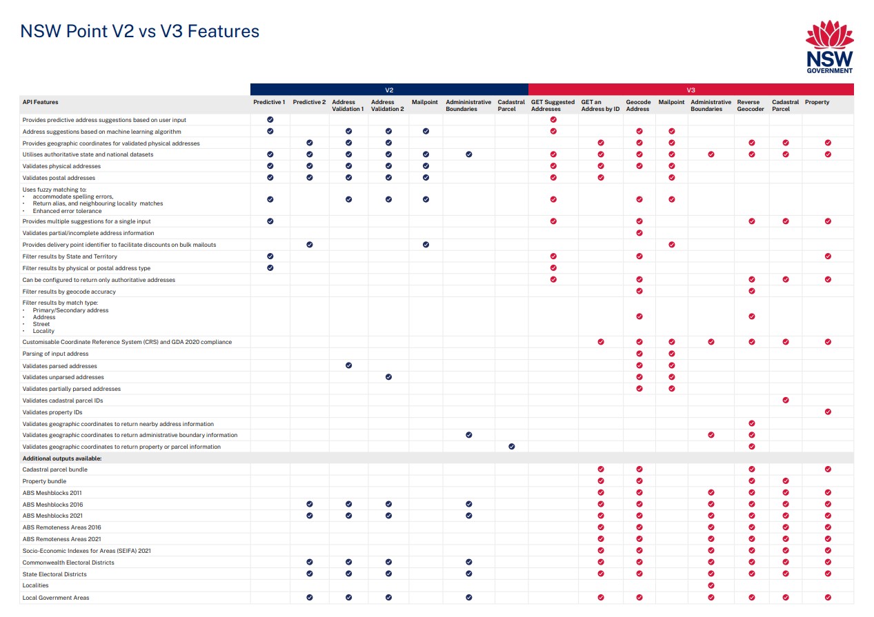
The comparison table below provides an overview of the features available in all NSW Point V2 and V3 APIs.
In accordance with our terms of use and currently policy, access is restricted to NSW State Government agencies.
NSW Point accesses the following address datasets:
- GNAF-Live database is updated nightly from the Australian jurisdictions (States and Territories).
- GNAF database is updated quarterly from the Australian jurisdictions and other National address contributors, such as Australia Post.
- Mail Address includes both physical and postal addresses available from Australia Posts’ Postal Address File and is updated quarterly.
- Test and Development
- Designed to try out the APIs in your application or project to see if they fit your requirements. Can be used for the development period of your use case. Also, can be used to view the outputs by unlocking the access from the API support. They are supplied for a trial period only and will be reviewed within 90 days.
- Production
- Before you release your application, please request a production API key by completing the Access Request Form. Production keys are throttled according to expected usage.
- Ongoing testing
- Many agencies run parallel environments (non-production) for monitoring and future development. Ongoing testing API keys will assigned to a low throttle usage limit, usually no more than 1000 requests per day.
All API keys are linked to a usage plan, based on throttle limits. API requests to our service is considered usage, for example keystrokes entered in the application to offer address suggestions. Consider the number of address fields within the application, which may be more than one. Allow five to ten transactions per validated address to estimate the usage. See next topic on transaction for further information.
Spatial Services uses Splunk software to collect all NSW Point usage on assigned API keys each month.
A transaction is: a request made to point.digital.nsw.gov.au/v2 URL using an assigned NSW Point API key. Includes all cs_method POST or GET request, and excludes status code of 500 (service error). Transactions will incur where status code 400 to 499 where an error is made by the client.
New agencies can receive a test and development API key for the trial period of 90 days free of charge.
Spatial Services will review the cost recovery model in the first quarter of each calendar year. This pricing structure will be shared with existing accounts in April, and current pricing information is always available by request from the NSW Point team.
New customers are required to estimate their usage when completing the Access Request Form. Upon submission of the form, our team will assess your expected usage and provide a quotation of fees.
Returning clients will have their costs included in the annual account, issued at the beginning of the financial year.
The cost recovery pricing model will be reviewed at the beginning of each calendar year, so fees may change year to year.
We suggest you considering the following to optimise performance and make best use of the APIs.
- One API key per application or form is recommended. Each API key is issued with throttle limits and use in multiple applications can result in a service failure due to exceeding the limits.
- Rotation of the API key every 12 months is recommended. This ensures currency of your nominated user details and improves security against the misuse of APIs.
- Keep the nominated user details current to ensure notifications are received. There may be service enhancements, maintenance and outages which are communicated to nominated users.
- Contact us if you have any questions about how to apply the API keys.
Prior to release the NSW Point V3 APIs have been through rigorous testing which included:
- Performance and reliability
- Penetration
- Load
Important: During implementation of your application or change, should there be a requirement to carry out additional testing this must be communicated prior to conducting by contacting us. We will need an outline of your plan at least one week prior which should include dates, timeframe and expected load. We may request this be scheduled outside normal business hours to reduce any risk of impact to performance of our API services (early morning or late evening).
A CRS is the geospatial system that is used for accurately determining position on the earth’s surface. Spatial data is usually captured and stored using specific CRS’s. When you want to display spatial data using a mapping application or platform, it is important to know the CRS used by the data, to ensure that it displays in the correct location.
All NSW Point APIs use GDA94 as the default CRS, however the following four commonly used, nationally recognised CRS are available as customisable options:
- GDA94 (Default)
- GDA2020
- WGS84
- AGD66
Understanding CRS is important for ensuring that the data you use is suitable for your end-user needs and applications. Further information on CRS see:
- Spatial Services - Map projections
- Geoscape - CRS and GDA-2020
No. NSW Point V3 uses a new API key authentication model. Existing V2 API keys will not provide access to V3 services.
If you are migrating to NSW Point V3, you will need to request and configure new V3 API keys for each application, integration, or project.
Yes, but only until the V2 decommission date of 30 September 2026.
After this date, V2 endpoints will no longer be supported. To maintain service continuity, you must update your applications and integrations to use NSW Point V3 endpoints.
NSW Point V3 includes new endpoints, enhanced functionality, and additional features not available in V2.
Pricing for NSW Point V3 is expected to remain aligned with current NSW Point pricing.
If any changes are introduced, customers will be notified in advance through standard communication channels.
Common Definitions, Terminology
| Term | Definition |
|---|---|
| address component | An individual element within an address. In NSW an address must contain the following minimum components to be considered valid: a unique street number (and sub-address number if appropriate), street name, suburb, state, and postcode. An address may also include other components such site name, level number or sub-address type, e.g., unit |
| address validation | Process of entering an address into an online form or application and retrieving the address data from NSW Point in a returned script with relevant components as requested. |
| ABS | Australian Bureau of Statistics |
| ASGS | Australian Statistical Geography Standard. Used by the ABS to define population and household regions |
| AV | Address Verification |
| batch | The process of undertaking bulk address verifications initiated though a single transaction. See Bulk Address Validation Services. |
| BAV | Bulk Address Validation Services. A service provided by DCS Spatial Services to NSW Government agencies includes the assessment, cleansing, validation, and geocoding of large volumes of address data. |
| coordinates | Geocode location, expressed in decimal degrees format. |
| CSV | Comma Separated Value. A file format used to store tabular data. |
| DPID | Delivery Point Identifier. A unique 8 digit code used for postal delivery services. |
| endpoint | The URL location for accessing a web service using a specific protocol and data format. |
| FSDF | NSW Foundation Spatial Data Framework |
| FSDI | Foundation Spatial Data Indexes |
| function | A web service that can be invoked with capabilities for searching and verifying addresses and providing other geospatial information. |
| fuzzy logic | Predictive services access machine learning to provide the most accurate and logical suggestions based on the client input. |
| geocode | Geographical co-ordinates; latitude and longitude |
| GeoJSON | A format for encoding a variety of geographic data structures. It is used in all NSW Point APIs that offer spatial data. https://geojson.org |
| G-NAF | The Geocoded National Address File. An index of physical Australian addresses, each with a geographic coordinate. Updated quarterly. |
| G-NAF Live | The Geocoded National Address File. Updated nightly from the Australian State and Territory address authorities. |
| jurisdiction | A state/territory regional authority responsible for the provision of geospatial data. |
| JSON | JavaScript Object Notation. Open-standard file format. |
| LGA | Local Government Area |
| MailAddress | A postal address data set accessed by Predictive services. Used to provide specifically postal address details, this service does not provide DPID. |
| mesh block | Mesh Blocks are areas defined by the Australian Bureau of Statistics (ABS). Geoscape source mesh block data from the ABS and are the smallest geographical unit within the Australian Statistical Geography Standard (ASGS). |
| NAMF | National Address Management Framework. A web service that supports the use of address information. |
| NCS | NAMF Notification and Compliance Service. |
| NWS | NAMF Web Service. A web service that supports the use of address information within the National Address Management Framework. |
| OGC | The Open Geospatial Consortium. A non-profit, international, voluntary consensus standards organisation that is leading the development of standards for geospatial and location-based services. |
| PAF | The Australia Post Postal Address File. A list of Australian addresses used for postal purposes. The PAF is only available through the AMAS (Address Matching Approval System) program and is used to support the efficient processing of mail through Australia Post's operational network. |
| parse/parsing | The process of separating individual components within a string of text into separate parts. For example, breaking up an address line into parts such as Number, Street Name, Street Type, Locality, State and Postcode amongst others. |
| predictive | Enhances customer experience to provide suggested address listing for the user to select. Based on key stroke entry, the list returns the most logical suggested addresses. |
| Geoscape | Geoscape Australia Limited, formerly known as Public Sector Mapping Agencies, is an unlisted public company wholly owned by the State, Territory and Australian Governments. It combines reliable spatial data from Australia's governments with leading-edge technology to create national spatial information datasets. |
| single address transaction | The validation of a single address using a combination of one or more NSW Point address-validation services. |
| SA | Statistical Areas. SA1, SA2, SA3 and SA4 are areas of population as defined by within the Australian Statistical Geography Standard (ASGS) as used by the ABS. |
| WFS | Web Feature Service. An OGC defined interface for requesting geographical features across the web using platform independent calls. |
| WMS | Web Map Service. An OGC defined interface for requesting Map images across the web using platform independent calls. |
API Attribution
| Attribute | Definition | API |
|---|---|---|
| type | Defines the type of GeoJSON Object delivered in the API response. Most NSW Point V3 Services will deliver a “Feature” (containing a single feature only) or a "Feature Collection" (containing 1 or or more features) Object. See GeoJSON Specification (RFC 7946) for further information. | Geocode Address, Administrative Boundaries, Reverse Geocoder, Property, Cadastral Parcel |
| features | An array containing 1 or more “feature” objects and attributes based upon the users request. The minimum expected inclusions in all “feature” object are:
|
Geocode Address, Administrative Boundaries, Reverse Geocoder, Property, Cadastral Parcel |
| features.type | Defines the type of GeoJSON Object delivered in the “featureCollection”. Most NSW Point V3 Services will deliver a “Feature” (containing a single feature only) Object. See GeoJSON Specification (RFC 7946) for further information. | Geocode Address, Administrative Boundaries, Reverse Geocoder, Property, Cadastral Parcel |
| features.[0].geometry | Object containing the geometry attribution (spatial information) for a feature. | Geocode Address, Administrative Boundaries, Reverse Geocoder, Property, Cadastral Parcel |
| features.[0].properties | JSON Properties object that contains attribution specific to each feature that is returned in the response. | Geocode Address, Administrative Boundaries, Reverse Geocoder, Property, Cadastral Parcel |
| features.[0].messages | String containing any messages (e.g., error details) for a specific feature that is returned by the API. | Geocode Address, Administrative Boundaries, Reverse Geocoder, Property, Cadastral Parcel |
| messages | String containing any messages (e.g., error details) for the featureCollection returned by the API. | Geocode Address, Administrative Boundaries, Reverse Geocoder, Property, Cadastral Parcel |
| attribution | Returns a legal attribution string for the data returned, which links to the Geoscape terms and conditions of usage. | Geocode Address, Administrative Boundaries, Reverse Geocoder, Property, Cadastral Parcel |
| query | Returns the information submitted in the request by the user that has elicited the API response e.g., the input address, coordinates, parcelId, propertyId, etc. | Geocode Address, Administrative Boundaries, Reverse Geocoder, Property, Cadastral Parcel |
| parsedQuery | Object containing a fully parsed version of the users input. Currently only returned by APIs that offer Address Validation. | Geocode Address |
| parsedQuery.siteName | Returns a parsed version of the specified address component from the input address that was submitted by the user in the request. | Geocode Address, Mail Point |
| parsedQuery.complexUnitTypeDescription | Returns a parsed version of the specified address component from the input address that was submitted by the user in the request. | Geocode Address, Mail Point |
| parsedQuery.complexUnitIdentifier | Returns a parsed version of the specified address component from the input address that was submitted by the user in the request. | Geocode Address, Mail Point |
| parsedQuery.complexLevelTypeDescription | Returns a parsed version of the specified address component from the input address that was submitted by the user in the request. | Geocode Address, Mail Point |
| parsedQuery.complexLevelNumber | Returns a parsed version of the specified address component from the input address that was submitted by the user in the request. | Geocode Address, Mail Point |
| parsedQuery.lotIdentifier | Returns a parsed version of the specified address component from the input address that was submitted by the user in the request. | Geocode Address, Mail Point |
| parsedQuery.streetNumber1 | Returns a parsed version of the specified address component from the input address that was submitted by the user in the request. | Geocode Address, Mail Point |
| parsedQuery.streetNumber2 | Returns a parsed version of the specified address component from the input address that was submitted by the user in the request. | Geocode Address, Mail Point |
| parsedQuery.siteName | Returns a parsed version of the specified address component from the input address that was submitted by the user in the request. | Geocode Address, Mail Point |
| parsedQuery.streetType | Returns a parsed version of the specified address component from the input address that was submitted by the user in the request. | Geocode Address, Mail Point |
| parsedQuery.streetSuffix | Returns a parsed version of the specified address component from the input address that was submitted by the user in the request. | Geocode Address, Mail Point |
| parsedQuery.localityName | Returns a parsed version of the specified address component from the input address that was submitted by the user in the request. | Geocode Address, Mail Point |
| parsedQuery.stateTerritory | Returns a parsed version of the specified address component from the input address that was submitted by the user in the request. | Geocode Address, Mail Point |
| parsedQuery.Postcode | Returns a parsed version of the specified address component from the input address that was submitted by the user in the request. | Geocode Address, Mail Point |
| requestTimestamp | Timestamp of the API request. | Geocode Address, Administrative Boundaries, Reverse Geocoder, Property, Cadastral Parcel |
| requestDateTime | Date and time of the API request. | Geocode Address, Administrative Boundaries, Reverse Geocoder, Property, Cadastral Parcel |
| geometry.coordinates | Returns the geographic coordinates (latitude and longitude) of the feature. | Geocode Address, Administrative Boundaries, Reverse Geocoder, Property, Cadastral Parcel, Predictive Address Validation 2, Mail Point |
| geometry.type | An attribute of a geometry object. Defines the type of geometry of an individual “Feature” Object in the GeoJSON response. Most NSW Point V3 Services will only offer “Point” geometries that consist of coordinate pairs e.g. Address geocodes. See GeoJSON Specification (RFC 7946) for further information. | Geocode Address, Administrative Boundaries, Reverse Geocoder, Property, Cadastral Parcel, Predictive Address Validation 2, Mail Point |
| properties.addressId | Returns the unique identifier for the address from its source dataset. | Geocode Address, Reverse Geocoder, Property, Cadastral Parcel, Predictive Address Validation 2 |
| properties.deliveryPointIdentifier | Returns the Australia Post Delivery Point Identifier (DPID) for the address. Used to assist in postal delivery services. | Geocode Address, Reverse Geocoder, Property, Cadastral Parcel, Predictive Address Validation 2, Mail Point |
| properties.barcode | Returns a series of alphanumerical characters that can be converted to an Australia Post “barcode” made up of vertical lines of specific variety of lengths. Used to assist in postal delivery services. | Geocode Address, Reverse Geocoder, Property, Cadastral Parcel, Predictive Address Validation 2, Mail Point |
| properties.formattedAddress | Returns all the address information in a single formatted string that is standardised to meet Australian guidelines for address presentation. | Geocode Address, Reverse Geocoder, Property, Cadastral Parcel, Predictive Address Validation 2, Mail Point |
| properties.postalDeliveryTypeCode | Returns the abbreviated code the defines the type of delivery location for postal addresses e.g. “PO BOX”. Source: Australia Post Data Guide - Glossary, p.31, Table: Postal Delivery Type Abbreviation | Geocode Address, Reverse Geocoder, Property, Cadastral Parcel, Predictive Address Validation 2, Mail Point |
| properties.postalDeliveryIdentifier | Returns the identifier for a postal address location e.g. “123” in “PO BOX 123”. | Geocode Address, Reverse Geocoder, Property, Cadastral Parcel, Predictive Address Validation 2, Mail Point |
| properties.siteName | Returns a name associated with the address that may refer to a business, building, complex, or specific location. | Geocode Address, Reverse Geocoder, Property, Cadastral Parcel, Predictive Address Validation 2, Mail Point |
| properties.complexLevelType | Returns the abbreviated code for a level within a multi-storey building e.g. L, G, B, etc. Source: GNAF Product Description - Appendix C, Table: LEVEL_TYPE_AUT CODES | Geocode Address, Reverse Geocoder, Property, Cadastral Parcel, Predictive Address Validation 2, Mail Point |
| properties.complexLevelTypeDescription | Returns the full text description for a level within a multi-storey building e.g. LEVEL, GROUND, BASEMENT, etc. Source: GNAF Product Description - Appendix C, Table: LEVEL_TYPE_AUT CODES | Geocode Address, Reverse Geocoder, Property, Cadastral Parcel, Predictive Address Validation 2, Mail Point |
| properties.complexLevelNumber | Returns the identifier for the specific level within a multi-storey building e.g. “10” in “LEVEL 10”. | Geocode Address, Reverse Geocoder, Property, Cadastral Parcel, Predictive Address Validation 2, Mail Point |
| properties.complexUnitType | Returns the abbreviated code for a sub-address site within a complex e.g. UNIT, APT, CARS, OFFC, etc. Source: GNAF Product Description - Appendix C, Table: FLAT_TYPE_AUT CODES | Geocode Address, Reverse Geocoder, Property, Cadastral Parcel, Predictive Address Validation 2, Mail Point |
| properties.complexUnitTypeDescription | Returns the full text description for a sub-address site within a complex e.g. UNIT, APARTMENT, CARSPACE, OFFICE, etc. Source: GNAF Product Description - Appendix C, Table: FLAT_TYPE_AUT CODES | Geocode Address, Reverse Geocoder, Property, Cadastral Parcel, Predictive Address Validation 2, Mail Point |
| properties.complexUnitIdentifier | Returns the identifier for a specific sub-address site within a complex e.g. “10” in “UNIT 10”. | Geocode Address, Reverse Geocoder, Property, Cadastral Parcel, Predictive Address Validation 2, Mail Point |
| properties.lotIdentifier | Returns a cadastral lot identifier that is considered part of the address information. Note: The use of Lot information for addressing purposes is deemed unacceptable within NSW according to the principles laid out in the NSW Addressing Policy and User Manual. However it is accepted in some other States and Territories within Australia. | Geocode Address, Reverse Geocoder, Property, Cadastral Parcel, Predictive Address Validation 2, Mail Point |
| properties.streetNumber1 | Returns the street number or first street number for a ranged address, including any prefix or suffix where applicable. | Geocode Address, Reverse Geocoder, Property, Cadastral Parcel, Predictive Address Validation 2, Mail Point |
| properties.streetNumber2 | Returns the second street number for a ranged address, including any prefix or suffix where applicable. | Geocode Address, Reverse Geocoder, Property, Cadastral Parcel, Predictive Address Validation 2, Mail Point |
| properties.streetName | Returns the recognised name for the street used in the address. | Geocode Address, Reverse Geocoder, Property, Cadastral Parcel, Predictive Address Validation 2, Mail Point |
| properties.streetType | Returns the abbreviated code for the type of the street. e.g. "AV", "RD", "ST", Sources: Appendix C, Table: STREET_TYPE_AUT CODES or Australia Post Data Guide - Glossary, p.29, Table: Street Type Abbreviation for Mail Point Addresses. | Geocode Address, Reverse Geocoder, Property, Cadastral Parcel, Predictive Address Validation 2, Mail Point |
| properties.streetTypeDescription | Returns the full word text for the type of the street used in the address e.g. "AVENUE", "ROAD", "STREET". Sources: Appendix C, Table: STREET_TYPE_AUT CODES or Australia Post Data Guide - Glossary, p.29, Table: Street Type Abbreviation for Mail Point Addresses. | Geocode Address, Reverse Geocoder, Property, Cadastral Parcel, Predictive Address Validation 2, Mail Point |
| properties.streetSuffix | Returns the suffix of a street name used in an address e.g. "WEST" in "SMITH STREET WEST". Source: GNAF Product Description - Appendix C, Table: STREET_SUFFIX_AUT CODES | Geocode Address, Reverse Geocoder, Property, Cadastral Parcel, Predictive Address Validation 2, Mail Point |
| properties.localityName | Returns the recognised name of the Locality/Suburb used in an address. | Geocode Address, Reverse Geocoder, Property, Cadastral Parcel, Predictive Address Validation 2, Mail Point |
| properties.stateTerritory | Returns the abbreviated name for the State or Territory used in an address. e.g. NSW, QLD, etc. | Geocode Address, Reverse Geocoder, Property, Cadastral Parcel, Predictive Address Validation 2, Mail Point |
| properties.postcode | Returns the postcode of an address as assigned by Australia Post. | Geocode Address, Reverse Geocoder, Property, Cadastral Parcel, Predictive Address Validation 2, Mail Point |
| properties.locationDescriptor | Attribute intended to support legacy addresses that include a description of a location as part of their address information e.g. REAR OF, UNDER THE BRIDGE, etc. | Geocode Address, Reverse Geocoder, Property, Cadastral Parcel, Predictive Address Validation 2, Mail Point |
| properties.jurisdictionId | Returns a unique identifier from the address dataset of the jurisdiction that is considered to be the Custodian of Address information for that State/Territory. For NSW addresses this is the GURASID from the Address String Table in the NSW Address Database. | Geocode Address, Reverse Geocoder, Property, Cadastral Parcel, Predictive Address Validation 2, Mail Point |
| properties.cadastralIdentifier | Returns the “parcelId” of the cadastral Land parcel that the address geocode resides within. See Geoscape Cadastre Product Guide for details regarding the construction of the parcelId/cadastralIdentifier attribute. | Geocode Address, Reverse Geocoder, Property, Cadastral Parcel, Predictive Address Validation 2 |
| properties.aliasPrincipal | Identifies whether the returned address is an Alias or Principal address according to business rules defined by Geoscape. | Geocode Address, Reverse Geocoder, Property, Cadastral Parcel, Predictive Address Validation 2 |
| properties.addressRecordType | Identifies whether the returned address is a Primary or Secondary address according to business rules defined by Geoscape. | Geocode Address, Reverse Geocoder, Property, Cadastral Parcel, Predictive Address Validation 2 |
| properties.geoFeature | Defines the type of "real world" feature from which the address coordinates are derived. Source: GNAF Product Description - Appendix C, Table: GEOCODE_TYPE_AUT CODES | Geocode Address, Reverse Geocoder, Property, Cadastral Parcel, Predictive Address Validation 2 |
| properties.dataset | A comma separated list of source datasets for the address information. | Geocode Address, Reverse Geocoder, Property, Cadastral Parcel, Predictive Address Validation 2 |
| properties.localityAlias | Returns a list of known alias names that may be in common-use for the Locality/Suburb. | Geocode Address, Reverse Geocoder, Property, Cadastral Parcel, Predictive Address Validation 2 |
| properties.localityNeighbour | Returns a list of all neighbouring Localities that share a common boundary with the Locality/Suburb used in the address. | Geocode Address, Reverse Geocoder, Property, Cadastral Parcel, Predictive Address Validation 2 |
| properties.localityId | A unique Identifier assigned to the Locality that is derived from Geoscape’s Administrative Boundary datasets. | Geocode Address, Reverse Geocoder, Property, Cadastral Parcel, Predictive Address Validation 2 |
| properties.streetLocalityId | A unique Identifier assigned to the Street and Locality combination that is derived from Geoscape’s Administrative Boundary datasets. | Geocode Address, Reverse Geocoder, Property, Cadastral Parcel, Predictive Address Validation 2 |
| properties.streetAlias | Returns a list of known alias names that may be in common-use for the Street used in the address. | Geocode Address, Reverse Geocoder, Property, Cadastral Parcel, Predictive Address Validation 2 |
| messages | Returns any general messages related to a specific feature or the featureCollection overall e.g. API error messages. | Geocode Address, Administrative Boundaries, Reverse Geocoder, Property, Cadastral Parcel, Predictive Address Validation 2, Mail Point |
| matchType | Broadly categorises the spatial accuracy of the address match that has been returned by the API. See Geoscape API Documentation for further matching information. | Geocode Address, Reverse Geocoder, Predictive Address Validation 2, Mail Point |
| matchQuality | Broadly categorises the quality of the address match that has been returned by the API. See Geoscape API Documentation for further matching information. | Geocode Address, Predictive Address Validation 2 |
| matchScore | A “score” that has been generated to define the accuracy of each suggested address match in the API response in relation to the input address that was submitted in the request. matchScore can be used to assist in understanding the “confidence” of a returned address. See Geoscape API Documentation for further matching information. | Geocode Address, Predictive Address Validation 2, Mail Point |
| matchDiagnostic | Diagnostic code of the returned match provided by Geoscape MailPoint API in accordance with AMAS certification and Australia Post Guidelines. | Geocode Address, Predictive Address Validation 2, Mail Point |
| matchDiagnosticMessage | Human readable mapping of diagnostic code of the returned match provided by Geoscape MailPoint API in accordance with AMAS certification and Australia Post Guidelines. | Geocode Address, Predictive Address Validation 2, Mail Point |
| matchCode.siteName | Indicates if the address component of an input address has been used for matching purposes and the type of match that has been made. Will only be present in the response if the input address includes this address component. Example values: “exact”, “fuzzy”, “phonetic”, “partial”, “in-range”, etc. | Geocode Address |
| matchCode.complexUnitTypeDescription | Indicates if the address component of an input address has been used for matching purposes and the type of match that has been made. Will only be present in the response if the input address includes this address component. Example values: “exact”, “fuzzy”, “phonetic”, “partial”, “in-range”, etc. | Geocode Address |
| matchCode.complexUnitIdentifier | Indicates if the address component of an input address has been used for matching purposes and the type of match that has been made. Will only be present in the response if the input address includes this address component. Example values: “exact”, “fuzzy”, “phonetic”, “partial”, “in-range”, etc. | Geocode Address |
| matchCode.complexLevelTypeDescription | Indicates if the address component of an input address has been used for matching purposes and the type of match that has been made. Will only be present in the response if the input address includes this address component. Example values: “exact”, “fuzzy”, “phonetic”, “partial”, “in-range”, etc. | Geocode Address |
| matchCode.complexLevelNumber | Indicates if the address component of an input address has been used for matching purposes and the type of match that has been made. Will only be present in the response if the input address includes this address component. Example values: “exact”, “fuzzy”, “phonetic”, “partial”, “in-range”, etc. | Geocode Address |
| matchCode.lotIdentifier | Indicates if the address component of an input address has been used for matching purposes and the type of match that has been made. Will only be present in the response if the input address includes this address component. Example values: “exact”, “fuzzy”, “phonetic”, “partial”, “in-range”, etc. | Geocode Address |
| matchCode.streetNumber1 | Indicates if the address component of an input address has been used for matching purposes and the type of match that has been made. Will only be present in the response if the input address includes this address component. Example values: “exact”, “fuzzy”, “phonetic”, “partial”, “in-range”, etc. | Geocode Address |
| matchCode.streetNumber2 | Indicates if the address component of an input address has been used for matching purposes and the type of match that has been made. Will only be present in the response if the input address includes this address component. Example values: “exact”, “fuzzy”, “phonetic”, “partial”, “in-range”, etc. | Geocode Address |
| matchCode.streetName | Indicates if the address component of an input address has been used for matching purposes and the type of match that has been made. Will only be present in the response if the input address includes this address component. Example values: “exact”, “fuzzy”, “phonetic”, “partial”, “in-range”, etc. | Geocode Address |
| matchCode.streetType | Indicates if the address component of an input address has been used for matching purposes and the type of match that has been made. Will only be present in the response if the input address includes this address component. Example values: “exact”, “fuzzy”, “phonetic”, “partial”, “in-range”, etc. | Geocode Address |
| matchCode.streetSuffix | Indicates if the address component of an input address has been used for matching purposes and the type of match that has been made. Will only be present in the response if the input address includes this address component. Example values: “exact”, “fuzzy”, “phonetic”, “partial”, “in-range”, etc. | Geocode Address |
| matchCode.localityName | Indicates if the address component of an input address has been used for matching purposes and the type of match that has been made. Will only be present in the response if the input address includes this address component. Example values: “exact”, “fuzzy”, “phonetic”, “partial”, “in-range”, etc. | Geocode Address |
| matchCode.stateTerritory | Indicates if the address component of an input address has been used for matching purposes and the type of match that has been made. Will only be present in the response if the input address includes this address component. Example values: “exact”, “fuzzy”, “phonetic”, “partial”, “in-range”, etc. | Geocode Address |
| matchCode.postcode | Indicates if the address component of an input address has been used for matching purposes and the type of match that has been made. Will only be present in the response if the input address includes this address component. Example values: “exact”, “fuzzy”, “phonetic”, “partial”, “in-range”, etc. | Geocode Address |
| pafVersion | Returns the version of the Australia Post - Postal Address File (PAF) data from which the address is derived. | Geocode Address, Predictive Address Validation 2, Mail Point |
| pafExpiry | The last permissible date of use by end-users of an Australia Post - Postal Address File (PAF) sourced address. | Geocode Address, Predictive Address Validation 2, Mail Point |
Match Quality Metadata
NSW Point uses Geoscape data and match quality information, for more information on Geoscape match quality, please refer to the following documents:
Additional Properties in NSW Point
The strength of the Foundation Spatial Data Indexes (FSDI) lies in their direct relationships to other key administrative boundary and spatial datasets. NSW Point offers an opportunity for data enrichment when you validate an FSDI reference (address, coordinate, parcel or property).
The additionalProperties parameter available in most NSW Point APIs, allows you to nominate the information you would like captured about your FSDI reference and have it returned in a single API response, avoiding the need for multiple calls.
The following additional properties are available for each address location:
- asgsMain - Australian Statistical Geography Standard (ASGS) information including meshblock and statistical areas 1-4. More information is available here.
- asgsRemoteness - Australian Statistical Geography Standard (ASGS) remoteness information. More information is available here.
- commonwealthElectorate - Commonwealth Electorate details. More information is available on Geoscape's National Product here.
- localGovernmentArea - Local Government Area details. More information is available on Geoscape's National Product here.
- seifa - Socio-Economic Indexes for Areas (SEIFA) information. More information is available here.
- StateElectorateBundle - Details of the current and future, state electorate. More information is available on Geoscape's National Product here.
- parcelBundle - Cadastral Parcel information. More information is available here.
- propertyBundle - Property Information. More information is available here.
Implementation Advice:
- Each
additionalPropertiesvalue added to a request impacts the API response time. Only include values that are essential to your business needs. - Most
additionalPropertiesare derived using a spatial intersection between an address point and an administrative area. Therefore,additionalPropertiesare only returned in API responses that include addresses or related address information. - The accuracy of
additionalPropertiesdepends on the precision of the address point "geoFeature" it's derived from. High-accuracy geoFeature types such as "BUILDING CENTROID" or "PROPERTY CENTROID" yield more reliable data than lower-accuracy features like "STREET LOCALITY" or "LOCALITY". TheminGeoFeatureLevelparameter available in some APIs, can be used to control/filter the spatial accuracy of address matching results.